
The feature marked Y North of Hatis is
Options:A) an ox-bow lake
B) an isolated hill
C) a depression
D) a sand bar
Show Answer
The correct answer is A .
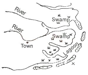
The feature marked X in the above sketch is formed by
Options:A) A headland erosion
B) marine regression
C) longshore drift
D) estuarine deposition
E) volcanic eruption
Show Answer
The correct answer is C .
A) warm moist wind blows over a warm current
B) warm moist wind blows over a cold current
C) cold, dry winds blows over a warm current
D) warm, dry winds blows over a cold current
Show Answer
The correct answer is B .
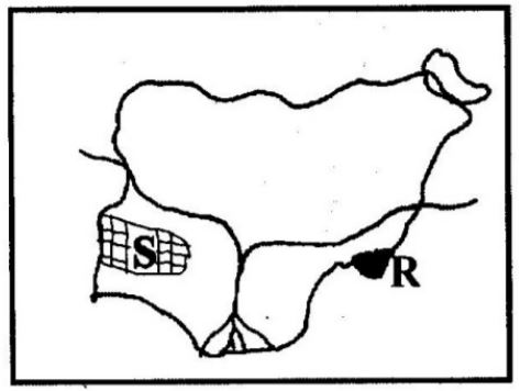
The area marked S is
Options:A) Western trough
B) Western upland
C) Obudu plateau
D) Oban hills
Show Answer
The correct answer is B .
A) rainguage
B) thermometer
C) hydrometer
D) barometer
Show Answer
The correct answer is A .
The time difference between a place on longitude 35oW and another longitude 25oE is
Options:A) 2 hours
B) 3 hours
C) 5 hours
D) 4 hours
Show Answer
The correct answer is D .
The length of the secondary road on the map is approximately
Options:A) 11.5km
B) 12.5km
C) 13.5km
D) 10.5km
Show Answer
The correct answer is C .
_______ is the condition of the lower atmosphere of a place over a short period
Options:A) Climate
B) Weather
C) Cloud
D) Humidity
Show Answer
The correct answer is B .
All except one is a disadvantage of compass traversing
Options:A) lack of technical experts
B) Its uses are complex
C) It can be used to survey a large area
D) The instrument used are expensive
Show Answer
The correct answer is C .
| J | F | M | A | M | J | J | A | S | O | N | D | |
| Temp.(oC) | 27 | 28 | 28 | 28 | 27 | 26 | 25 | 26 | 26 | 26 | 27 | 28 |
| Rainfall (mm) | 32.5 | 52.5 | 132.5 | 225.0 | 270.0 | 370.5 | 385.0 | 295.0 | 427.5 | 427.5 | 110.0 | 10.0 |
The climatic data above is likely to be that of
Options:A) Warri
B) Lokoja
C) Ibadan
D) Kaduna
Show Answer
The correct answer is B .