Nigeria is located between longitudes
Options:A) 3°E and 15°E
B) 2°E and 15°E
C) 1°E and 10°E
D) 3°E and 10°E
Show Answer
The correct answer is A .
A) Bida
B) Jos
C) Erin-Ijesa
D) Omu-Aran
Show Answer
The correct answer is C .
Which of the following is not a proof of the earth's sphericity?
Options:A) The circular horizon
B) deflection of winds
C) ship's visibilty
D) circumnavigation of the earth
Show Answer
The correct answer is B .
Identify the pair of forces/processes which may be responsible for the formation of rift valleys
1. Centrifugal 2. Erosional 3. Compressional 4. Magnetic 5. Faulting.
Options:A) 1 and 5
B) 2 and 3
C) 3 and 4
D) 3 and 5
E) 1 and 3
Show Answer
The correct answer is D .
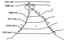
In which direction will the winds blow?
Options:A) clockwise
B) ani-clockwise
C) parallel to the isobars
D) at right angle to the isobars
Show Answer
The correct answer is A .
A) bad farming practice and mulching
B) intensive cultivation and cover crops
C) bad farming practices and fertilizers
D) intensive cultivation and overgrazing
Show Answer
The correct answer is D .
A) compression and movements
B) joints and faults
C) compression and tension
D) joints and cracks
Show Answer
The correct answer is B .
A) Amazon
B) Mississipi
C) Niger
D) Nile
E) Indus
Show Answer
The correct answer is D .
The coastal regions of Sierra Leone record an annual rainfall of over
Options:A) 5,000mm
B) 3000mm
C) 4,800mm
D) 6,500mm
Show Answer
The correct answer is C .

The shaded areas labelled Y on the map are noted for
Options:A) Dry season wheat cultivation
B) Floodland rice cultivation
C) Large-scale fish farming
D) Large-scale irrigation farming
Show Answer
The correct answer is B .